
India: Relief Features
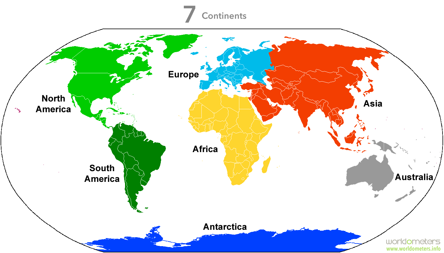
Let us talk about the present world map. We have 7 continents. What are continents? The Continent is a large solid mass of earth. The seven continents of the world are:: (from bigger size to smaller size)
Asia
Africa
North America
South America
Antarctica
Europe
Australia
There are five oceans in the present world. They are
The Pacific ocean
The Atlantic Ocean
The Indian Ocean
The Southern Ocean (Antarctic Ocean)
The Arctic Ocean

What is the difference between the Sea and the Ocean? Please note that seas are smaller in size and oceans are bigger in size. Seas are part of oceans, we say When the part of Ocean meets the land then it is said to be sea. The Bay of Bengal is the sea because it touches the land and it is a part Indian Ocean. The Mediterranean Sea is the largest sea located on earth. Try to locate it on your atlas? Atlas is a book where the collection of maps is stored.
Longitudes: (Also called as Meridians) Longitudes are the vertical imaginary lines drawn on the globe. The center Longitude of the earth is called Prime Meridian or Greenwich latitude (0⁰ Longitude)
Latitudes: (also called as Parallels) Latitudes are horizontal imaginary lines drawn on the globe.
The center latitude of earth is the Equator. Take the help of your teacher for better understanding the latitudes and longitude.
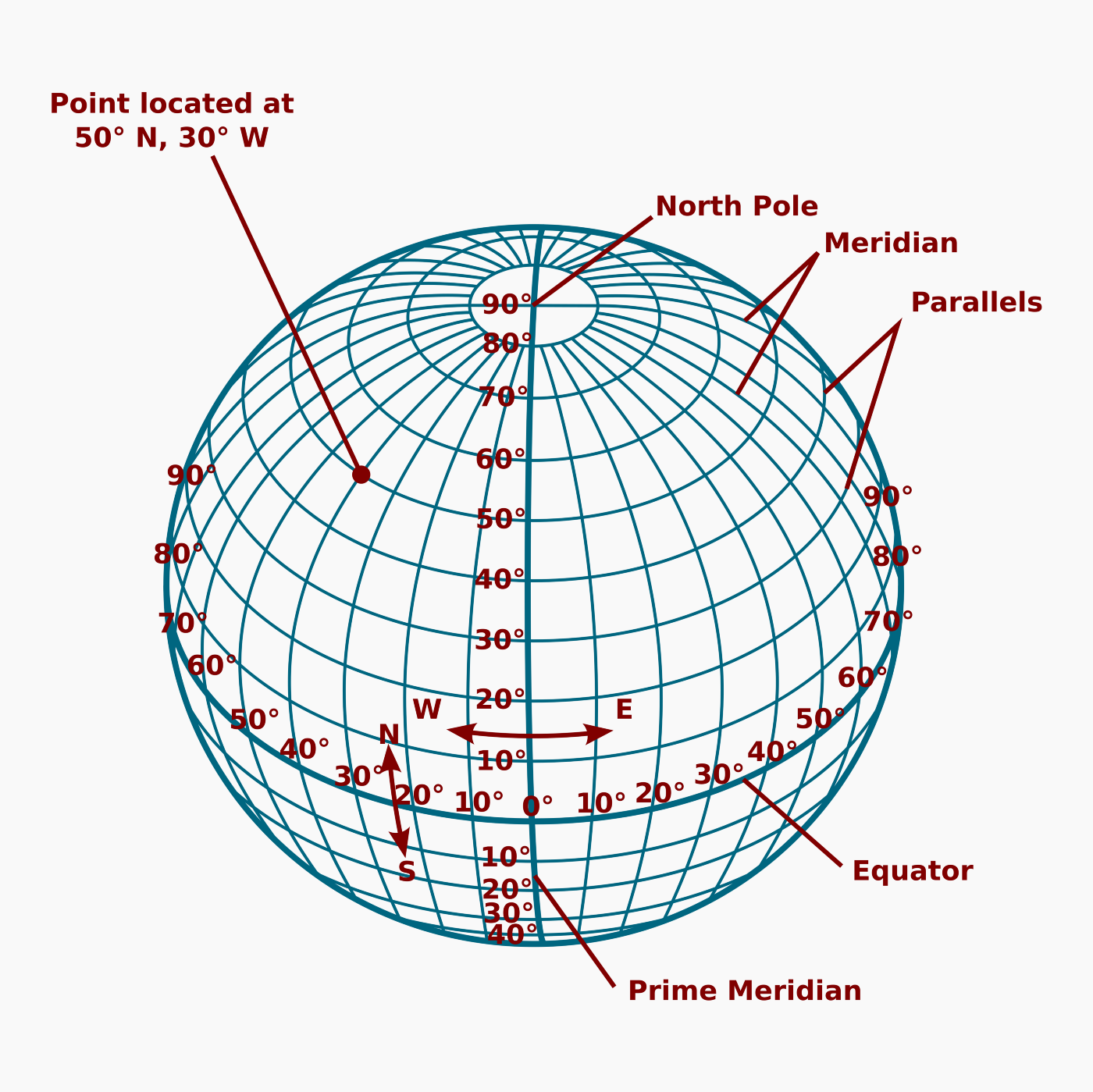
What are grids? Grids are the networks of intersection of latitudes and longitudes. You see the square boxes in the picture above. These square boxes are called Grids.
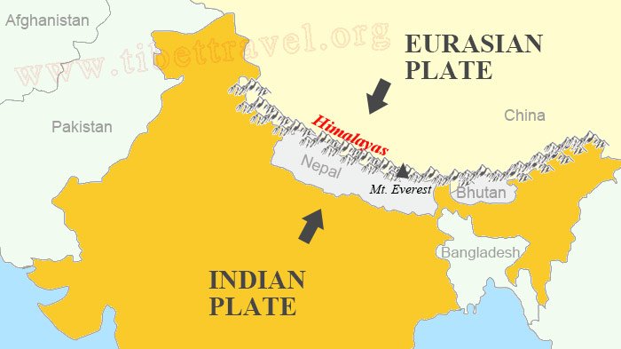
How are the Himalayas formed?
World landforms originated from two giant lands namely Angora land(Laurasia) and Gondwana land.
The Indian landmass was a part of Gondwana land.
Over 200 million years ago Gondwanaland split into pieces and the peninsular Indian plate moved towards the North East and collided with Eurasian plate.
Due to collision force between the two plates there formed the folds which are the present form of Himalayas.
This process took millions of years to form the Himalayas.
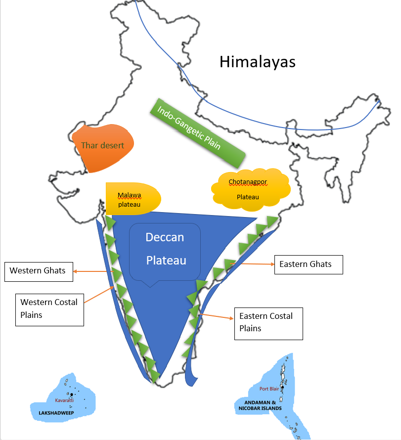
Major Relief divisions of India::
The Indian landmass can be divided into 6 groups. These are the Relief divisions of India.
The Himalayas
The Indo-Gangetic Plain
The Peninsular Plateau
The Coastal plains
The Desert
The Islands
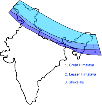
The Himalayas::
The Himalayan range runs from west to east in the top of India with a distance of about 2400 KMs. The Himalayas consist of three parallel ranges. They are
Greater Himalayas or Himadri
Lesser Himalayas or Himachal
Outer Himalayas or Shivaliks
Greater Himalayas::
The northernmost range is known as Greater Himalayas or Himadri. The average height of the Greater Himalayas is 6100 meters above mean sea level.
The Greater Himalayas are composed of snow and ice. We find glaciers here.
The Greater Himalayas are the source of Perennial rivers.
Lesser Himalayas::
The portion of range from south of Greater Himalayas is called Lesser Himalayas or Himachal. The lesser Himalayas' height ranges from 3700 to 4500 meters.
Lesser Himalayas are composed of highly compressed rocks.
The Pirpanjal and Mahabharata ranges are important ranges of Lesser Himalayas.
This region is well known for many hill stations like Simla, Mussoorie, Naintal, Ranikhet etc.
This region is covered by Evergreen Forest.
Outer Himalayas::
The Southernmost range of Himalayas is called Outer Himalayas or Shivaliks. The average height of Shivaliks is 900 to 1100 meters.
Shivaliks ranges have different names in different regions.
Jammy Hills (in Jammu region)
Mishmi Hills (in Arunachal Pradesh)
Cachar Hills (in Assam)
What are the benefits of having the Himalayas?
What is the influence of the Himalayas on Indian Agriculture?
Himalayas act as barriers protecting the great plains of India from cold winds of Central Asia during winter.
Himalayas are the source of Perennial rivers. If there were no Himalayas there would be no Perennial rivers. If there were no Perennial rivers India would turn to desert.
Himalayas form a natural barrier that prevent monsoon winds from going further north.
The Himalayas are responsible for summer rains.
In which states the Himalayas are present?
Jammu and Kashmir
Himachal Pradesh
Nagaland
Meghalaya


0 Comments